Here, we will describe the geography of Chhattisgarh and also explain the geographical facts of Chhattisgarh. As we know, Chhattisgarh is an important state in India and is also known for its mineral resources and uprisings.
What is the geography of Chhattisgarh?
General introduction of Chhattisgarh
- State Emblem: A circular symbol protected by 36 garhs (forts), in the center of which is the Ashoka Pillar, the symbol of India. Along with the motto Satyamev Jayate, golden earrings of paddy, the main crop of the state, and waves depicting the rivers of Chhattisgarh, along with the three colors of the national flag, are among the symbols of energy.
- Foundation Day: November 1, 2000 (26th state)
- Capital: Raipur (Atal Nagar proposed)
- Official language: Hindi
- State Tree: Sal
- State animal: buffalo
- State Bird: Hill Myna
- Government motto: ‘Truth and transparency’
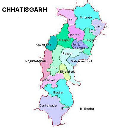
The geographical structure of Chhattisgarh
- Location: The state is situated between 17°46′ north latitude and 24°5′ north latitude and 80°15′ east longitude and 84°20′ east longitude.
- Area: 136,194 square kilometers (Data: From the official website of the Government of Chhattisgarh)
In terms of total geographical area, the state of the country is 10th. - Position of the state in the Indian Union: 26
- The geographical boundary touches the borders of seven states (Jharkhand, Uttar Pradesh, Odisha, Madhya Pradesh, Maharashtra, Andhra Pradesh, and Telangana).
- North-South length: 360 km
- East-West Width: 140 km
- Most populous district: Raipur
- District with the minimum population: Narayanpur.
- Natural divisions: hilly region, plateau region, plain region, plain entry.
- Climate: tropical monsoon climate.
- The shape of the state: seahorse-like.
Administrative and political structure of Chhattisgarh
- Number of districts: 27 (Announcement to make Gaurila-Pendra Marwahi the 28th district)
- Division: 5
- Municipal Corporation: 13 (Proposed 14th Municipal Corporation of Risali State)
- District Panchayat: 27
- Legislature: unicameral
- Number of Assembly members: 91 (this includes one Anglo-Indian member)
- Number of Lok Sabha members: 11
- Number of Rajya Sabha members: 5
- High Court: Bilaspur
- Of the 11 Lok Sabha seats in the state, 1 has been reserved for Scheduled Castes and 4 for Scheduled Tribes.
- The state assembly building is named after Minimata
- The name of the residence of the State Assembly Speaker is Sanveda
- Name of the residence of the Chief Minister of the State: Karuna
- State Police Headquarters: Raipur
- State Police Motto: Paritranaya Sadhunam
- The Police Training Academy has been established in the state at a place called Chandrakhuri in Raipur district.
- Central Jail is located in Raipur, Bilaspur, Jagdalpur, Durg, and Ambikapur.
The only open jail in the state is located in Masgaon, Bastar district.

Pingback: What is the concept of pragmatism in geography? - Geography Study
Pingback: Natural vegetation of Chhattisgarh - Geography Study
Pingback: Folk songs of Chhattisgarh - Geography Study