Arab geographers made significant contributions to the field of geography during the medieval period. They made valuable contributions to geographical thinking, including concepts, paradigms, and theories that are still relevant today.
Arab geographers were interested in geography due to their geographical surroundings, and their knowledge was much wider and enriched than that of Christian scholars.
Contribution of arab geographers in geography/Contribution of arab scholars in geography
Arab geographers made significant contributions to geographical knowledge during the mediaeval period. Arab scholars, in contrast to Christian scholars, emphasised direct observation and logical deductions, conforming their conclusions to near realities.
Between 800 and 1400, Arab geography was enriched and expanded as a result of a variety of factors, including the spread of Islam and the consolidation of Arabic-speaking people. Arab scholars based their geographical texts on a broader range of sources than their Christian counterparts.
The spread of Islam aided Arabs in learning about the lands and peoples they conquered, and Arab geography flourished in Baghdad, the Arab world’s intellectual centre.
Al-Balkhi, Al-Masudi, Al-Maqdisi, Al-Biruni, and Ibn Sina made important observations in the fields of climatology and physical geography during this period.
contribution of Arab scholars’ work is discussed:
Al-Balkhi
- Arab scholars made significant contributions to climatology and physical geography during the early mediaeval period.
- Their ideas are still relevant in modern geographical thinking.
- They made significant observations about climate and the processes that shape landforms.
- Al-Balkhi gathered climatic data from various Arab travellers who made direct observations during their expeditions and journeys in 921.
- Based on the collection of climatic data, Al-Balkhi created the world’s first climatic atlas, Kitab al-Ashkal.
Al-Masudi
- Al-Masudi was a ninth-century scholar who travelled south of the equator as far as Mozambique.
- During his voyage along the East African coast, he developed a concept of the monsoon based on empirical observations of the climate.
- Al-Masudi understood moisture evaporation from water surfaces and moisture condensation in the form of clouds.
- He believed in the Earth’s sphericity and described how the environment affected people’s attitudes and lifestyles.
- Al-Masudi believed in environmental determinism.
Al-Maqdisi
- In 985, Al-Maqdisi created a new climatic map of the world with 14 climatic regions, which improved on the Previous AL- Balkhi’s map.
- Al-Maqdisi believed that a regional climate varied not only with latitude but also with its east-west orientation.
- He also proposed that the southern hemisphere was mostly open, with the northern hemisphere containing the vast majority of the world’s land area.
Al-Biruni
- Al-Bakhi, Al-Masudi, and Al-Maqdisi made important contributions to climatology, whereas Al-Biruni and Ibn-Sina made significant contributions to geomorphology.
- Al-Biruni, who visited India during the reign of Mahmud Ghaznavi, wrote the great geography of India “Kitab-al-Hind,” which deals with the processes that shape landforms in India.
- He recognised the significance of rounded stones in alluvial deposits and observed coarse alluvial materials closer to the mountains and finer alluvial materials farther away.
- Al-Biruni also noted the absence of night at the South Pole, most likely based on accounts of earlier explorers.
Avicenna or Ibn Sina
- Based on his observations of mountain streams cutting down valleys in Central Asia, Avicenna or Ibn Sina is credited with the concept of landscape erosion.
- He hypothesised that mountains were constantly being eroded by streams, with the highest peaks occurring where rocks were particularly resistant to erosion.
- Mountains are raised and immediately subjected to a gradual but steady deterioration process.
- Ibn Sina also noticed the presence of fossils in high mountain rocks, which he interpreted as evidence of nature’s failed attempt to create living plants or animals.
- Eight centuries later, James Hutton presented similar ideas about erosion, but he had probably never heard of Ibn Sina and could not read Arabic.
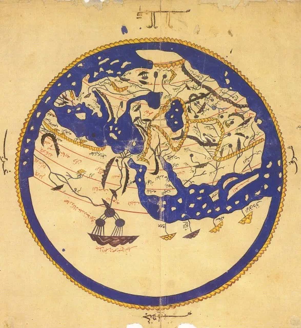
Al-Idrisi
- For the first time, Al-Idrisi made extensive corrections to Ptolemy’s incorrect geographical ideas.
- He believed that the actual arrangement of mountains, rivers, and coastlines was uncertain.
- Al-Idrisi created a new geography based on a wealth of new data.
- Al-Idrisi corrects Ahmud Ptolemy’s idea of the enclosed Indian Ocean and the Caspian Sea as a gulf of the world ocean in his book “Amusement For Him Who Desires to Travel Around the World.”
Ibn-Battuta
- Abdullah Muhammad, also known as Ibn-Battuta, was a mediaeval traveller born in Tangier in 1304.
- He went on a pilgrimage to Mecca at the age of 21, but his interests shifted to exploring North Africa and Egypt on the way.
- He was enthralled by nature and abandoned his law studies to travel across then-Arab territory.
- He avoided taking the same route twice and saw many parts of Africa that had never been seen before.
- He sailed along the Red Sea, visited Ethiopia, and travelled south along the East African coast to Kilwa, which is nearly 10 degrees south of the equator.
- He discovered an Arab trading post at Sofala in Mozambique, which was more than 20 degrees south of the equator, confirming that the torrid zone in East Africa was not torrid, but was inhabited by a large native population.
- Ibn-Battuta travelled from Mozambique to Mecca, then to Baghdad, Persia, and the Black Sea region.
- He crossed Russia, went to Bukhara and Samarkand, crossed Afghanistan, and entered India.
- He served as an ambassador to China after spending several years at the Mongol emperor’s court in Delhi.
- He visited the Maldives, Ceylon, and Sumatra before travelling to China, and he stayed in China for a shorter period of time.
- In 1350, he returned to Fez, Morocco’s capital, and travelled to Spain before returning to Fez.
- In 1351-53, he travelled across the Sahara to Timbuktu, gathering vital information about the Arab Negro tribes who lived in that region of Africa.
- In 1353, he settled in Fez and began writing a detailed account of his travels.
- During his thirty years of travel, he covered approximately 75,000 miles in a straight line, a world record at the time.
- Unfortunately, his book was written in Arabic and had little impact on the Christian world because it was never translated into Latin.
Ibn-Khaldun
- Ibn-Khaldun was the mediaeval period’s last great Islamic geographer, writing between 1382 and 1405.
- Through his analysis of empire rise and fall, he laid the groundwork for political geography.
- He was born on the Mediterranean coast of northwest Africa, like Ibn-Battuta, and spent the majority of his life in Algeria, Tunisia, and the Arab part of Spain.
- In 1377, he finished Muqaddimah, a massive introduction to his world history that is the most detailed autobiography available in medieval Arab history.
- Ibn-Khaldun discusses humankind’s physical environment and its influence on Muqaddimah, as well as the characteristics of humankind that are related to her/his culture or way of life.
- Ibn-Khaldun concentrated on the most powerful units in his time’s political hierarchy, the tribe and the city, and explained their differences deterministically in terms of livelihood choice.
- Ibn-Khaldun investigated the operations of two types of sociopolitical organisations: Bedouins and sedentary people.
- He claimed that the Bedouins were courageous, alert, and loyal, whereas the sedentary people lacked these qualities and represented immobile concentrations of wealth.
- His generalisations about the Bedouin and sedentary states/political organisation were founded on empirical data.
- For security against attack and self-government, sedentary states had to develop new and complex systems of political organisation.
- Although the two types of socio-political organizations were interdependent, the sedentary state ruled economically and politically.
- Ibn-Khaldun is credited with developing the first concept of state life cycles, which is still relevant in tribal Africa and Asia.
- Ibn-ideas Khaldun’s about the ekumene and other aspects of climatic determinism appeared to be derived from earlier Greek concepts.
- He accepted the traditional seven climatic zones parallel to the equator and reiterated Aristotle’s idea of an uninhabitable equatorial zone due to intense heat and an inhabitable polar zone due to cold.
- Ibn-Khaldun agreed with Albertus Magnus that people became black when they lived too close to the sun and gradually white when they moved to the temperate zone.
- His understanding of the physical Earth is largely based on Greek theory, and his ideas about environmental influence are simple.
Some other important facts
- In the mediaeval period, Arab geographers emphasised the importance of direct observation and made significant contributions to geographical knowledge.
- Unlike their Christian counterparts, some Arab scholars made logical deductions from existing theories, and their conclusions corresponded to near realities.
- Between 800 and 1400, the Arab geographic horizon was enriched and broadened by a variety of sources and events, including the spread of Islam and the consolidation of Arabic-speaking people.
- The spread of Islam brought the previously isolated wandering tribes of Arabia together, providing a sense of unity that aided in the development of Arab geography.
- Arab scholars’ geographical writings were based on a much broader range of sources than Christian scholars’.
- Muslims set out to conquer the world outside of Arabia, including Persia, Egypt, the Iberian Peninsula, India, and parts of Southeast Asia.
- Their military expeditions assisted the Arabs in learning about the land and people they conquered, which expanded their geographic knowledge.
- Arab geography thrived in Baghdad, which was founded by Arabs near the ruins of Babylon in 762 and became the intellectual centre of the world for more than a century.
- With the patronage of Caliph Harun al-Rashid, Arab scholars translated the works of Greek philosophers and scholars into Arabic, resulting in a flood of new ideas throughout the Arab world.
- The decimal arithmetic system was brought to Baghdad by Hindus and adopted by Arab scholars.
- Arab scholars were fascinated by Greek traditions and concepts, such as the idea of the Earth being at the centre of the universe, with celestial bodies moving in a circular motion.
- Baitul-Hukma (Academy) scholars attempted to recalculate the circumference of the Earth in the direction of Al-Mamum.
- They used the same method as Eratosthenes and calculated the circumference of the Earth to be 20,160 miles, which was much less than Eratosthenes’ calculation.
- The Mediterranean Sea was considered the western limit of the known ekumene by the Arabs, while Sila (Japan) was considered the eastern limit.
- The Arabs of mediaeval Arabia had access to Greek translations and their own travel reports, which provided them with more accurate knowledge of the world than their counterparts.
- Ibn-Haukal, an early Arab traveller, explored remote regions of Africa and Asia and discovered large populations of people living in latitudes thought to be uninhabitable by the Greeks.
- The observations of Ibn-Haukal challenged the Greek concept of the habitable zone, but it persisted in various forms for a longer period of time.


Pingback: Coral reefs and atolls - Geography Study